Alaska Water Level Watch

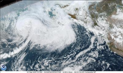
  • Ex-Typhoon Merbok Post-Storm Data Response

    Sept. 15, Extratropical Typhoon Merbok transited the Bering Sea impacting 40 Alaska Native communities and more than 1,300 miles of coastline. Visit this site to see the story about the post-storm data collection effort that was immediately coordinated...

    What Was the Biggest Flood We Had?

    The Alaska Division of Geological & Geophysical Surveys works with Alaska Water Level Watch partners to maintain photos and resources on historical floods in western Alaska. These resources are the only insights into how high past floods reached in...

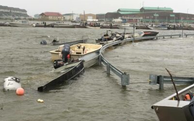
    Water Level Sensor Installed to Monitor Flooding at Kwigillingok

    October 22, 2021 By Jacquelyn Overbeck, Alaska Division of Geological & Geophysical Surveys Early in spring of 2021, the community of Kwgillingok experienced coastal flooding from a high tide (see https://www.kyuk.org/post/kwigillingok-experi...

    Alaska Coastal Mapping Strategy Supports Addressing Deficiencies in Water Level Network

    July 6, 2020 By Jacquelyn Overbeck, Alaska Division of Geological & Geophysical Surveys The Alaska Mapping Executive Committee (AMEC)—a coordinated working group amongst federal agencies as well as the State of Alaska—recently released a ...

    VDatum Efforts in Alaska

    Southeast Alaska Model Release/Update The VDatum 4.0.1 release on October 28, 2019 includes support for transformations involving the tidal datums of southeast Alaska (SE AK): local mean sea level (LMSL), mean lower low water (MLLW), mean high water (...

    Coastal Storm Hits Western Alaska. In February.

    February is not a normal time of year for coastal storms to be flooding western Alaska. With another year of record low sea ice extents in the Bering Sea (NSIDC, 2019), however, the coast remains vulnerable to low-pressure systems moving across the ocean.

    Summer Surge on Kotzebue Sound

    In July 2018, the Alaska Division of Geological & Geophysical Surveys Coastal Hazards Program conducted coastal surveys at Kotzebue and Deering, Alaska to inform the elevation data used to create color-indexed flood communication maps. While survey...

    UAF Deploys Storm Surge Monitoring Tripods in Three Northwest Coastal Communities

    Northwest Alaska is no stranger to large fall storms. From October until the sea ice arrives, the region experiences multiple coastal storms each year that heavily impact the region leading to inundation and coastal erosion.

    Re-installation of the Tununak iGage

    Alaska Division of Geological & Geophysical Surveys and Anchorage National Weather Service (NWS) staff travelled to Tununak to re-install a water level sensor that was damaged in winter of 2015.

    Alaska Water Level Watch Features archive

  • Welcome

    The Alaska Water Level Watch (AWLW) is a collaborative group working to improve the quality, coverage, and accessibility to water level observations in Alaska’s coastal zone.

    Water level data has many applications that contribute to safe navigation, storm modeling and mapping, tsunami warnings, watches, and advisories, incident response, search and. rescue operations, tidal datums, sea level trends, storm trends, and much more.

  • Contact Us

    For more information regarding the Alaska Water Level Observing Network, contact Jacquelyn Overbeck, National Oceanic & Atmospheric Administration Office for Coastal Management:

  • Water Level Build-Out Plan

    Identify existing sensor assets, remaining gaps, and updated priorities in this web map. Also access other information and tools about water levels like the most up-to-date projections of relative sea level rise.

  • Access & Contribute Data

    Alaska Water Level Watch is a forum for crowd-sourced water level data. Data are contributed and accessed through the AWLW data portal.

    Contributing data is easy! Use our station log template and instruction forms to provide metadata with your water level data.

  • Search Photos of Past Storms