
Background
 The Local Environmental Observer (LEO) Network is an organization of tribal professionals in Alaska and Canada who share information about environmental events where they live, post observations on public maps and coordinate with technical experts to identify appropriate actions. The LEO Network documents time and local specific events and encourages communication between communities, academic institutions and resource agencies. The purpose is to increase understanding about climate and other drivers of change and to develop appropriate adaptation strategies. To achieve this, LEO applies traditional knowledge, western science and modern technology to form a robust and effective environmental health surveillance system. The LEO Network is hosted by the Alaska Native Tribal Health Consortium, Center for Climate and Health and is supported by the Environmental Protection Agency and Landscape Conservation Cooperatives.
The LEO Network is composed largely of tribal environmental, natural resources and health professionals who share observations about events that are unusual or unique and locally relevant. The network has compiled a database of observations on topics including extreme weather, floods, erosion, ice changes, permafrost thaw, invasive species, infrastructure damage, environmental contamination, and changes in the health, range, and behavior of fish, insects, birds and wildlife.
LEO participants post observations, photos and video to a simple, web-based form. Content is reviewed at the Center for Climate and Health at the Alaska Native Tribal Health Consortium. The information is then posted to Google maps. A new map is developed each month and the observations are listed in chronological order. A year end map is developed with a summation of all the observations.
Maps are also developed by topic and by region, and all maps are archived on the LEO website.
How to view the LEO observations
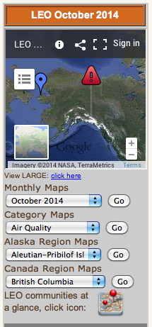 The maps can be accessed from the right-hand side of the LEO website. You can choose to view the map by month or year, category (e.g. air quality, fish, ice, etc.), or region. Choose which map you would like to view from the drop-down menus and press “go”. A Google map will appear that contains all the events reported by local LEO professionals for that time-frame or category. The box to the left of the map contains a chronological list of all the observations posted. You can click on any event in that list, or the events on the map (represented by the blue icons) and a text box will appear that contains information on the date, time, location and details of the observation. The box also may include photos, video clips, links and attachments (such as a pdf document) related to the event. LEO managers can also add information to the event posting, including links to technical assistance providers, information on the next steps taken on the event and follow up information.
All events posted on LEO maps are also transferred to Excel spreadsheets that provide a method for sorting by observer, community, time and type of observation. The spreadsheets are updated monthly and publically available on the LEO website.
How to join LEO
 To become a LEO you must work in the environmental, environmental health, natural resource, planning, or health field for a tribe, tribal organization, first nation, or partner LEO host organization. Contact LEO.
There is also a LEO Youth program that matches local youth with participating LEO organizations to help share observations from the youth perspective. Check the list of LEO communities on the home page for LEO Youth opportunities where you live.