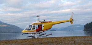
Click to enlarge
During each mapping session, a biologist and geologist ride in a helicopter above the coast to document shore characteristics and record video and still imagery. ShoreZone coverage now includes almost 100,000 km of coastline from Alaska, British Columbia, Washington and Oregon.
The first Alaska ShoreZone imaging survey of 2013 started this weekend on St. Lawrence Island south of the Bering Strait. The survey takes place from July 20-24, and will include geomorphic and biological resource mapping in addition to low-tide-oblique aerial imagery.
This effort will allow users to “fly the coastline” (video), view still photos, and access biophysical data using interactive web applications. Most of Southeast and Southcentral, and part of the Aleutian Islands and the Alaskan Arctic have already been mapped, and the data is publicly accessible.
- Visit the ShoreZone website
- Integrate ShoreZone information with other data (AOOS Data Portal)
- View the St. Lawrence Island mapping flyer
Update from the Field- July 21st
ShoreZone biologist, Mary Morris, reports:
“We were able to survey part of Maknik Lagoon (southeast shore), then had to move up to the shoreline near Northeast Cape and lagoons there. We refueled at camp at Northeast Cape and worked back towards Savoonga…the down drafts from the strong south winds over the cinder cones and lava fields just east of Savoonga kept us way offshore at the end of the day but we did manage to collect the imagery okay.
Huge lagoon and barrier island complexes. Juxtaposition of volcanics and tundra, similar perhaps to Iceland? Lava flows right to the ocean east of Savoonga, with columnar basalt cliffs at the waters edge, most with huge bird colonies, extending for kilometers along the shore. Beaches of different colored sands, with black to grey to beige colors in different sections of the coast.
Dune grasses and beach greens with extensive log lines in some sections, many areas of dense rockweed on the bedrock/boulder headlands, evidence of underwater nearshore benthic algaes too, esp near Northeast Cape.”
