
Community-based monitoring and citizen science programs are expanding throughout Alaska. These programs allow local people to participate in the scientific process and observe environmental phenomenon on front lines of change.
Community Based Monitoring Workshop
AOOS and Alaska Sea Grant are hosting a two-day workshop on April 1-2, 2014, to identify and respond to common issues for CBM in Alaska. Participants will hear from model programs, clarify top priorities for funders and community members, develop a set of guidance documents—including Best Practices and Lessons Learned—and network with others across the state who are interested in or are actively doing this work. Anyone interested in CBM of Alaska’s Coastal Environment is encouraged to participate and you can learn more here: http://seagrant.uaf.edu/
Featured Programs in Alaska
Yukon River Inter-Tribal Watershed Council (YRITWC)
-
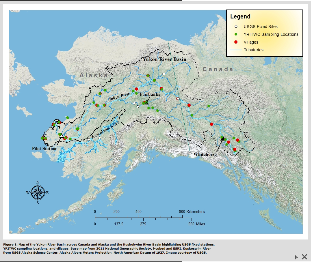
Map of the Yukon River Basin across Canada and Alaska and the Kuskokwim River Basin highlighting USGS fixed stations, YRITWC sampling locations, and villages. Base map from 2011 National Geographic Society, i-cubed and ESRI, Kuskoswim River from USGS Alaska Science Center, Alaska Albers Meters Projection, North American Datum of 1927. Image courtesy of USGS.
The Yukon River Inter-Tribal Watershed Council is an Indigenous grassroots organization, consisting of 70 First Nations and Tribes, dedicated to the protection and preservation of the Yukon River Watershed. The YRITWC facilitates a basin-wide Indigenous Observation Network (ION) which operates 39 fixed station water quality sites with the help of over 100 local technicians and engagement with 23 Indigenous governments. ION also operates an Active Layer Network that monitors seasonal active layer dynamics at over 20 locations throughout the watershed.
The current sample sites collect data on pH, water temperature, conductivity and dissolved oxygen, major ions, toxic metals, nutrients, dissolved organic carbon, greenhouse gasses, water isotopes and Indigenous Knowledge. and are located in: Atlin, Teslin, Carcross, Carmacks, Whitehorse, Mayo, Dawson, Eagle, Circle, Fairbanks, Fort Yukon, Venetie, Arctic Village, Nenana, Kotlik, Huslia, Koyukuk, Galena, Ruby, Anvik, Marshall, Russian Mission, Pilot Station, St. Mary’s, St. Michael, Chevak, Kotlik, Hooper Bay and Stebbins. Active layer sites can be found on the map
- Focus: Basin scale water quality observations to monitor change in water chemistry and permafrost and formally set baseline conditions.
- Coverage: See map, above.
- Contact: Ryan Toohey
Bering Sea Sub-Network (BSSN): International Community-based Observation Alliance for Arctic Observing Network

BSSN community map. Eight villages are active in the BSSN observer program.
BSSN is a means for remote indigenous villages around the Bering Sea to communicate ![]() their observations on the environment and subsistence harvest. Their perspective, based on a keen understanding of the local environment and how it affects their well-being, improves the understanding of coupling of social and bio-physical environment at a local scale. BSSN brings together researchers and local residents in co-production of science, which is place-based and relevant to the societal needs.
their observations on the environment and subsistence harvest. Their perspective, based on a keen understanding of the local environment and how it affects their well-being, improves the understanding of coupling of social and bio-physical environment at a local scale. BSSN brings together researchers and local residents in co-production of science, which is place-based and relevant to the societal needs.
- Focus: Local environmental and temporal observations
- Coverage: Eight remote indigenous villages around the Bering Sea in Alaska and Russia
- Contact: Victoria Gofman
Coastal Observation and Seabird Survey Team (COASST)
COASST sees a future in which all coastal communities contribute directly to monitoring local marine resources and ecosystem health through the establishment of a network of citizen scientists, each collecting rigorous and vital data. Data collection includes beach-cast carcasses of marine birds to establish the baseline pattern of bird mortality. The data collected helps address important marine conservation issues and protect marine resources.
- Focus: Sea bird mortality
- Coverage: Southeast Alaska, Aleutians, Bering Sea, Gulf of Alaska, and Chukchi Sea
- Contact: Jane Dolliver

Cook InletKeepers regional map.
Cook Inletkeeper’s Citizens’ Environmental Monitoring Program
In 1996 Cook Inletkeeper developed the Citizens’ Environmental Monitoring Program (CEMP) – to actively involve citizen volunteers in the collection and distribution of important habitat and water quality data for the Kachemak Bay and Anchor River watersheds. Volunteers monitor and report on water quality, tracking significant changes monitoring quality trends. Over 300 volunteers in the homer area have been trained as water quality monitors.
- Focus: Long term water quality monitoring
- Coverage: Cook Inlet watershed
- Contact: Rachel Lord
ANTHC’s Local Environmental Observer (LEO) Network

LEO has 100 observers in over 60 communities.
The Local Environmental Observer (LEO) Network is run by the Alaska Native Tribal Health Consortium (ANTHC), and is comprised of local experts who share their knowledge and  experiences to describe environmental events in their communities. They apply local and traditional knowledge and modern technology to share their observations and raise awareness about the changing conditions of the circumpolar north. LEOs are connected with technical experts to increase communication and understanding about our changing environment. Observations are then mapped using and interactive interface on the ANTHC website.
- Focus: Notable environmental events or observations
- Coverage: Over 80 communities throughout Alaska and Canada
- Contact: Mike Brubaker
Sea Ice for Walrus Outlook (SIWO)

Squares indicate Alaska Walrus hunting locations.
SIWO was started in 2010 as an activity of  the SEARCH Sea Ice Outlook, and is a resource for Alaska Native subsistence hunters, coastal communities, and others interested in sea ice and walrus. The SIWO provides weekly reports from April through June with information on sea ice conditions relevant to walrus in the Northern Bering Sea and southern Chukchi Sea regions of Alaska. These reports are issued through the contributions of local hunters and Alaska Native sea-ice experts, weather and ice forecasters, climate scientists and sea-ice researchers at NOAA, the National Weather Service, the University of Alaska, the Arctic Research Consortium of the U.S., and the Eskimo Walrus Commission.
- Focus: Sea ice
- Coverage: Northern Bering and southern Chukchi Seas
- Contact: Kristina Creek
Alaska Corps of Coastal Observers (AkCCO)
 The emerging Alaska Corps of Coastal Observers (AkCCO) is a new training and support resource to facilitate a network of community based observers to track and monitor weather and shore-line processes. A partnership between the Alaska Sea Life Center and UAA School of Engineering, observers will use hand held instruments and a computer to provide regular oceanographic observations. AkCCO program support personnel will work with institutions, agencies and local communities to develop sustainable funding mechanisms to train and deploy community observers as part of the statewide coastal network.
- Focus: Weather and shore-line processes
- Coverage: As of July 2013, the AkCCO Advisory Board is choosing one test site to pilot the program
- Contact: Howard Ferren
Whales & Glaciers Science Adventure
 With the help of several local non-profits, the Alaska Sea Grant Marine Advisory Program, the University of Alaska Fairbanks, NOAA, Project Budburst, and the Alaska DEC, Gastineau Guiding Company created this first of its kind tour program to look for ways to foster connections between citizens and science. Through collaborative efforts with their research partners, objectives including sampling phytoplankton to identify possible “red tide” outbreaks, contributing photographs to aid in the identification of area whales and mammals, providing baseline data for several researchers throughout the state of Alaska, and contributing to online citizen science databases utilized by researchers around the country. During each summer season cruise line travelers’ direct participation and observation can give a little something back, deepening the understanding of local wilderness and wildlife.
- Focus: Baseline data on humpback whales, whale ID, phytoplankton sampling, phenology observations, water quality testing
- Coverage: Southeast Alaska
- Contact: Gastineau Guiding Company
Recreational Shellfish Monitoring Program
The Recreational Shellfish Monitoring Program is designed to create partnerships with  communities near popular recreational shellfish collection beaches to establish a community program to monitor commonly harvested shellfish for paralytic shellfish toxins (PST) and to educate the community about the results of the sampling. This program also includes community outreach and education regarding PST and paralytic shellfish poisoning (PSP). A consortium of partners on the Southern Kenai Peninsula were selected to conduct this program and who have committed to a three-year period.
- Focus: Shellfish and paralytic shellfish toxins
- Coverage: Ninilchik, Port Graham Bay, Kachemak Bay, Kodiak
- Contact: Terry Thompson