
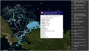
This Research Assets Map shows the location of sampling efforts throughout Alaska.
One of 11 ocean observing regions nationwide, AOOS works across public, private, academic and business communities to identify priorities and gaps in existing ocean observing activities; make recommendations for needed enhancements to both Federal and non-Federal assets; and fill gaps when appropriate to meet priority needs in Alaska.
Observing Assets: Existing ocean observing assets and data are available through various interactive maps and data discovery tools including the Research Assets Map (top) and AOOS Real-Time Sensor Map (bottom). The Research Assets Map is a visual inventory of marine and coastal monitoring instruments and efforts in time. The map can be queried by time period, what is being measured, or who owns the instrument.
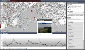
This Real-time Sensor Map streams data from instruments like buoys, moorings and weather stations.
Real-time Data: The Real-time Sensor Map taps into more than 4,000 sensors owned and maintained by a variety of federal, state and private entities. To search across Alaska’s waters, users can filter the information that is displayed by type of sensor or measurement, station type or source of information.
Additional information about the types of sensors, platforms and technologies used to measure and deliver data – in real time or with less frequency (depending on the needs and constrains on particular research efforts) follows in the sections below.
Components of the Observing System
Observing systems consist of sensors that collect data, the platforms that host these sensors, and technology that sends the data to a data collection center, often with satellite telemetry. Usually, the choice of what platform or instrument to use to collect observations depends on where and what you are interested in measuring. Below you will find a brief description of some of the types of observations that are collected here in Alaska.
Surface Measurements 
Subsurface Measurements
Sea Ice and Coastal Observations
Ocean Acidification
Weather and Climate
Connecting Observations and Models
Using observations of the past and present state of the oceans and coasts, together with knowledge of how these systems work, we can fill in some of the gaps in space and time, and predict future conditions. Numerical models, such as those which generate the “virtual sensor” allow us to infer information for places, times, and/or variables that we are unable to measure directly, and to forecast how the environment will change over time. Dynamical models are based on equations thought to describe the interactions among various parts of a natural system and their response to different types of forcing. All models use observations to initialize, drive and constrain results along their boundaries. Such “observationally constrained” models provide a cost-effective approach to obtaining high spatial and temporal resolution depictions and predictions of coastal and open ocean conditions.