

Click to enlarge
The Tununak water level station is seen here through the AOOS real-time sensor map. Users can expand the graph for higher resolution data.
With the help of partnerships, better data on water levels in western Alaska is reaching those who need it. With AOOS funding, AK DNR’s Division of Geological & Geophysical Surveys (DGGS), in cooperation with the National Weather Service, has instrumented two bridges near communities along the Bering Sea with sensors to monitor water levels in brackish areas near the open ocean. Unalakleet and Tununak received gauges which will document storm surge and tidal water level variation and enhance the NWS storm surge forecasts in this region.
The data are also available in real- time for use by other agencies and the public. Check out the Unalakleet and Tununak stations through the AOOS data portal.
Primary funding for this pilot instrumentation effort came from AOOS with additional help from the Coastal Impact Assistance Program (CIAP). The project compliments another effort (funded by BOEM) to deploy a suite of tide gauges (water level recorders) to acquire year-long records of local sea level at Pt. Hope, Pt. Lay, Wainwright, Barrow, and Kaktovik. These measurements, along with those acquired by NOAA gauges at Red Dog and Prudhoe Bay, will be used to address the specific goals of:
- Improving our understanding of ocean circulation and improving computer models of ocean circulation in the Chukchi and Beaufort Seas;
- Investigating relationships between landfast ice breakout events and sea level changes;
- Assessing the effects of sea level changes on coastal erosion; and
- Obtaining data necessary for coastal protection and engineering design issues.
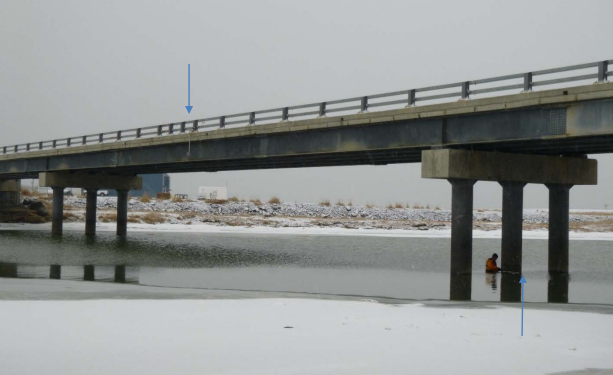
This photo of the Unalakleet bridge shows locations of instrumentation providing data on water levels.
Water level data is extremely limited in rural Alaska due to harsh environmental conditions and high costs of installing instruments. This project seeks to develop an adaptive methodology for the instillation of short-term water level stations that can help make water level measurements in the Arctic more affordable. This pilot project will foster bilateral communication at the Federal and State level to test an integrated water level network in coordination with NOAA’s National Water Level Observation Network, which will help to meet the needs of Alaska stakeholders and to improve water level records statewide.