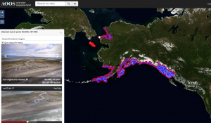
Click to enlarge
Thousands of miles of coastline from the ShoreZone Alaska database have now been added to the AOOS portal. Users can "fly the coast" for any region with a highlighted coastline. Imagery for the North Slope will be available later this summer.
Thanks to the ShoreZone Alaska project, AOOS users can now “fly the coast” through a number of new regions including Prince William Sound, the Alaska Peninsula, Bristol Bay, Southeast, and the northwest Arctic. After clicking on the flight line in the AOOS Ocean Data Explorer, two windows automatically appear streaming video for the specific location, and displaying still photos. Users have the option of changing the video resolution from high to low resolution depending on bandwidth, and can hop to a new area of coast at any time. The strength of the AOOS system lies in the ability to overlay ShoreZone imagery with other types of data (e.g. real-time sensors, species distribution, forecast models, land ownership, etc).
More on ShoreZone
ShoreZone is a mapping and classification system that specializes in the collection and interpretation of low-altitude aerial imagery of the coastal environment. Through partnerships between NOAA and a number of other agencies and organizations, the majority of Alaska’s coastline has now been imaged and mapped. The objective is to produce an integrated, searchable inventory of geomorphic and biological features of the intertidal and nearshore zones which can be used as a tool for science, education, management, and environmental hazard planning. The ShoreZone mapping system provides a spatial framework for coastal habitat assessment on local and regional scales. Imagery now exists for over 100,000 km of coastline from Alaska, British Columbia, Washington and Oregon. The Alaska ShoreZone coastal mapping program is a partnership of scientists, GIS specialists, web specialists, nonprofit organizations, and governmental agencies. A full protocol of ShoreZone is available at www.shorezone.org.
