
Click to enlarge
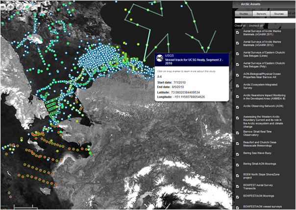
The research assets map shows the locations of planned and existing instruments and monitoring sites across the state with a focus on the Arctic.
A new version of the Arctic Research Assets Map has been released! The map has expanded to include assets in western Alaska and Canada, and has new capabilities to help users personalize their view. Explore the new features of the assets map, give us feedback with the feedback link, or submit your instruments.
Browse the Updated Map
New Features
- Polar projection!
- Browse by studies or station types, in addition to sensors and sources.
- New search bar: type in a search term to query the map
- Ability to select and highlight specific assets
- Transect lines and polygons are represented by a midpoint until highlighted
- Option to change background base layer
- Ability to add or subtract data layers for a personalized view
- Save or share your own view by creating a bookmark link
New Studies Featured
- Chukchi Sea Environmental Studies Program – 2012 baseline (joint industry funded)
- RUSALCA monitoring stations
- RUSALCA cruise tracks
- CCGS Sir Wilfrid Laurier – 2012-Three Oceans cruise tracks
- Healy Cruise tracks
- Bering Strait AON Moorings
- O-Buoy Network of Chemical Sensors
- Terrestrial linkage to climate and metazoan
- COMIDA – Chukchi Sea Monitoring in Drilling
- Monitoring Subsistence Fisheries in the Elson Lagoon
- Canada’s Three Oceans (C3O) – Distributed Biological Observatory (DBO) programs
- The Western Arctic Boundary Current and its role in the Arctic ecosystem and climate change
- Mapping in Nautilus Basin in Support of Delimiting an Extended Continental Shelf
- CHAOZ – Chukchi Acoustic Oceanography and Zoo-plankton
More About the Map

Scientific research activity in Alaska’s Arctic has increased substantially in the last few years. AOOS has responded to a need for a visual inventory of the locations and types of oceanographic information being collected by creating a web-based, interactive map that allows users to display Arctic research information of interest. It is also a first step towards providing greater access to the variety of data collected by numerous parties, including industry.
The Research Asset Map was developed and is maintained by the AOOS Data Team. Thanks to NOAA, the University of Alaska, the University of Washington, the US Bureau of Ocean Energy Management, the National Science Foundation, Conoco Phillips, Shell Oil, and many others for contributing information about their instruments.