Oil spill response and the search and rescue of vessels and people in the Sound and on the high seas are reliant upon accurate and timely surface current information. Computer simulations can greatly improve the response time to marine accidents. However, the forecasts provided by computer models need to be tested against observations and measurements in the ocean.
Field Experiment Drifter Operations
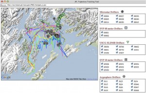
Four types of drifting buoys were used: Argosphere drifters made by Metocean Data Systems, Surface Velocity Program (SVP) drifters made by Pacific Gyre, Microstar drifters also made by Pacific Gyre, and the U.S. Coast Guard (USCG) Self Locating Data Marker Buoy (SLDMB) made by Metocean.

Drifters were deployed at the beginning of the Field Experiment and traveled the Sound until the experiment ended August 3.
These drifters were deployed in groups that contain at least three of each style of drifter. During the main study periods the drifters were released at three sites: 60 35N 146 56W, 60 35N 146 47W, and 60 31N 146 56W. The first location listed is where drifters were deployed in the 2004 experiment.
By using three locations we provided a spread to check the model results. Drifter positions were situated to maximize time in the cyclonic circulation that was observed in 2004. In 2004 the primary drifter trajectory was a cyclonic circulation with the drifters leaving the circulation pattern from the northern and western edge. The drifters were picked up if they left a circle 10 nm in radius with 60 35N 146 56W as the center of the circle. Once picked up they were redeployed at their original starting locations.
Mark Halverson explains the importance of understanding ocean circulation
During the period between the two main observation times the drifters were used to test circulation in other parts of the system, such as starting at a more northwestern location where the freshwater flow is expected to be greater. They were also deployed within the HF-radar viewing area with a smaller watch circle used to pick up and redeploy the drifters. This was done to allow better quantification of the dispersion of the drifters from a grid cell of the model or HF radar footprint.
Drifter position were monitored through Argos and Iridium telemetry as well as hand-held receivers. A file with at least hourly drifter positions was provided to AOOS each evening before 10 p.m. ADST.
Technical Information about the Drifters
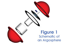
Argospheres (Figure 1) are 28-cm diameter spherical buoys designed to track oil floating on the water. Position determination is through the Argos satellite system and a GPS receiver. For the GPS positions, an accuracy of +/- 10 m is normal. Position updates will be obtained at 0.5-hour intervals. A hand-held tracking unit will be used to provide location information in the field.
SVP drifters (Figure 2) are 38-cm diameter spherical buoys to which a drogue is attached, and they are expected to drift with the water at the depth of the center of the drogue. The drogue is a holeysock 2.5 m in height and positioned to be centered at 10 m. Location determination is through the Argos satellite system and GPS receiver.
Microstar drifters (Figure 3) are designed to track the  mean current at a depth of about 1 meter. The key elements of the drifter include the drogue, the surface float and the connecting tether. The drogue acts as a sea anchor locking the drifter to a parcel of water. The surface float contains the telemetry system, antenna, batteries and sensors. Drifter positions are calculated by an onboard GPS receiver. Positions are transmitted to the user providing the information necessary to calculate mean current velocities and direction.
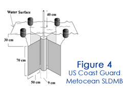
The Metocean SLDMB (Figure 4) used by the USCG is designed specifically for deployment from a vessel or aircraft and for unattended operation during a 30-day lifetime. The SLDMB is accompanied by an onboard electronics package which includes GPS positioning. Service Argo, Inc, receives the data and forwards it to the National Oceanic and Atmospheric Administration polar-orbiting n-series satellites every 3 0 minutes. The data is transmitted to a secure USCG website for use by trained Search and Rescue Personnel. The USCG uses these drifters to construct current vectors from sequential SLDMB positions. In conjunction with the Search and Rescue Optimal Search Planning System (SAROPS) the USCG is able to establish the ocean surface motion and use this to better predict the motion of vessels and people during search and rescue operations.
The first PWS field experiment in 2004 used drifting buoys to measure ocean currents in the Sound. The results showed a strong horizontal circulation of water moving counterclockwise around the central basin. Mathematical models predict a similar circulation around the perimeter of the Sound. During the second field experiment in 2009, drifting buoys were used again to test the accuracy and precision of the computer forecasts.


