Since the mean tidal range in PWS is about three meters, all mariners need to consider the currents created by the ebb and flood of the tides. When winds and waves are also factors, the velocity of the currents can magnify waves to dangerous heights.
High-Frequency Radar
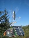
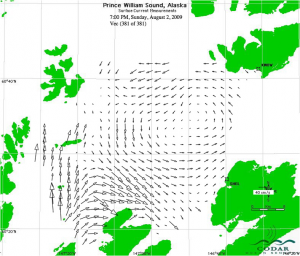
High Frequency (HF) radar is one tool that can be used to directly measure surface current velocities. An array of instruments in PWS measures the direction and speed of surface currents in the central basin and transmits this information to the data management group.
The HF radar is a combination of a powerful radio wave transmitter and receiver that use the Doppler shift to determine how fast surface currents are traveling.
The stations transmit and receive radio waves that travel as far as 60 km across the Sound in all directions. As each radio wave reflects off the ocean and returns to the receiver, changes in the waves’ Doppler frequency shift is determined and then used to estimate the surface currents. Two sites combine to determine the surface horizontal velocity field.
In mid-summer of 2004 the stations began to reveal something that had never been directly measured before: the counter-clockwise flow that include inflow through Hinchinbrook Entrance and outflow into the head of Montague Strait. The HF radar data from 2004 along with a series of drifter trajectories also from 2004 are now being more thoroughly analyzed at UAF. The cyclonic circulation pattern is likely a consequence of the inflow of dilute Alaska Coastal Current water through Hinchinbrook Entrance, inflow of freshwater from the Sound’s surrounding coast, and the basin-like bathymetry of the central Sound.
Coast Guard instrumental in emergency HF Radar repair during 2009 Field Experiment
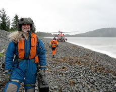
Ongoing stormy conditions in July 2009 made conditions challenging for the HF radar team. They needed to travel out to Knowles Head for field repair of the stations but were kept ashore by high seas.
Logistics queen Nancy Bird at the Prince William Sound Science Center came to their rescue and contacted the U.S. Coast Guard, a partner in the Storm Predictions project. The Coast Guard provided equipment and personnel to fly technicians Steve Sweet and Hank Stascewich out to the site. There, they were able to reset, refuel and reboot the radar station and get data delivery back online.


