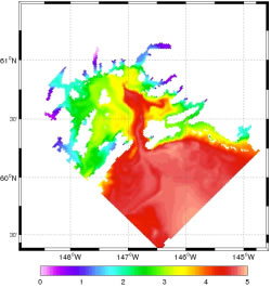
Just as meteorologists forecast the behavior of the atmosphere, scientists are using the information gathered from the Prince William Sound Observing System to predict the behavior of the ocean waters of the Sound and the waters that flow through it.
ROMS: Understanding ocean dynamics in the Sound
Ocean circulation in Prince William Sound is driven by an intricate mixture of buoyancy, wind, tidal, and remote forcing. A research team led by Dr. Yi Chao from the Jet Propulsion Lab and including Dr. Xavier Capet from UCLA has developed a Regional Ocean Modeling System (ROMS) for the Sound that can simulate the behavior of currents, tides, salinity, and temperatures at any time during the year.
Zooming in
The group has created three scales of measurement, with the largest measuring the Gulf of Alaska, and the smallest focused on the Sound. As the area of measurement decreases, the resolution increases to as little as 1.2 square km. Why the different scales? “If we want to model what is going on inside the Sound properly, we need to know what is going on outside the Sound,” Capet said.
Discoveries to Date
Preliminary studies that have been done in the Sound support other scientists’ theories of a stable counter-clockwise gyre that is particularly strong in the summer. It also clearly shows the movement of a warmer current from the south as is passes along the coast in the winter.
Most importantly, what the model shows is that conditions in the Sound vary greatly from one location to another, and also vary greatly from one time to another.
What’s Next
After validating the model, the team will quantify water exchanges between the open ocean and the Sound, including residence time in the Sound and mean fluxes through Hinchinbrook entrance. The preliminary ROMS implementation for the Sound, Cook Inlet, and the nearby Gulf of Alaska coastal oceans shows very encouraging results when compared to observational data from moorings and drifters.
Technical information about the ROMS Model
In September 2004, UCLA and JPL ocean labs were asked to design a numerical framework to help advance the knowledge of Price William Sound (PWS) ocean dynamics. Ocean circulation forecasts and error estimates are based upon a nested series of spatial domain models using the Regional Ocean Modeling System (ROMS).
ROMS uses a terrain-following vertical coordinate and represents the current state-of-the-art. Specifically, UCLA’s responsibility is to build a PWS configuration of ROMS nesting capability. 3 nested grids have been generated with a mesh size of 11, 3.6 and 1.2km encompassing respectively the whole Gulf of Alaska, the central coast of Alaska and PWS (the latter extends to the Copper River delta to make sure this important source of freshwater for PWS is included at the finest scale).
The circulation in the Sound is driven by an intricate mixture of buoyancy, wind, tidal and remote forcing. A number of technical issues have been overcome and we are currently in the early phase of validation of all grid levels. Further requirements (synoptic winds, improved bathymetry for the region of PWS) will be needed but the numerical solutions (1 year for the 3 grid levels) already reproduce some interesting features. The eddy present in the central part of the Sound during most of summer 2004 is also a robust feature in the model even when forced by climatological monthly winds and in the absence of freshwater inputs. We will investigate the mechanisms responsible for the occurrence of this eddy.
The structure of the currents across Hinchinbrook Entrance shows strong baroclinicity and temporal variability in relation to the mesoscale activity present outside PWS on the slope. We will undertake a full quantification of the PWS/open ocean exchanges (residence time in the sound, mean fluxes through Hinchinbrook entrance) after a validation procedure using the existing dataset across Hinchinbrook entrance. Our preliminary ROMS implementation for the PWS/CI and the nearby Gulf of Alaska coastal oceans shows very encouraging results when compared to observational data from moorings and drifters.


