
Click to enlarge
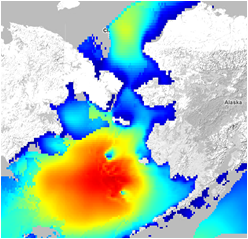
Significant wave height exceeded 30 ft (area in red) on Nov 8th, as modeled by NOAA and displayed in the AOOS Model Explorer
A sever winter storm moved through the Bering Sea the week of Nov. 7th, affecting many communities along western Alaska. The AOOS Model Explorer helped visualize forecasted wind, waves, and precipitation both before, during, and after the storm. The models are produced by NOAA and the Alaska Regional Supercomputing Center, and are updated several times per day. By using the Model Explorer's 'time slider' function, viewers can see visual forecasts from previous time periods, including the crux of the storm on Nov 8th.

The AOOS Real-time sensor map shows water level in Nome exceeding 2 meters at 12pm on Nov 9th
Additionally, real-time conditions can be viewed through the AOOS real time sensor map. Readings include wind, temperature, water level, barometric pressure, precipitation, and other parameters.
Significant Wave Height (current forecast)
NOAA Wave Watch III Model
Loading chart