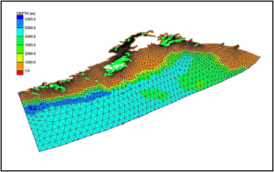
Modeler: Ray Chapman, US Army Corps of Engineers
Funding Entity: US Army Corps of Engineers Alaska District, and The Port of Anchorage
- Input: Bathymetry, tidal constituents
 and river flow for model operations. Water surface gauge and ADCP currents measurements for calibration and verification.
 - Scope: Northern Gulf of Alaska, Cook Inlet, Knik and Turnagain Arms
- Resolution: Two-dimensional depth averaged, hours to months
- Timeline: Started in 2005, completed in 2010
Strengths: Non-structured large regional grid. Parallel processing computation.
Weaknesses: Two-dimensional barotropic
Additional Data Needed: Water surface gauge and ADCP currents measurements for additional calibration and verification at other locations within Cook Inlet.

